1886
Help Wanted
Oklahoma Trails has several counties and projects up for adoption. If you would be interested in adopting a county or project look at the Oklahoma Trails. If you find one that you would like to adopt e-mail the State Administrator or Assistant State Administrator.
[ Being a County or State Administrator is fun and rewarding. If you have an interest in the history of Oklahoma and the genealogy of it's residents please consider it. If you think "there is no way I can do this" there are many people ready, willing and able to help you. It's not near as difficult as you might think. ]
History
In the Compromise of 1850 the state of Texas ceded to the U.S. government a vast region claimed by Texas since its days as a republic. The cession was apportioned by 1854 among the new territories of New Mexico, Kansas, and Nebraska. An early proposal for Kansas Territory's southern boundary was to have it run along the northernmost Texas state line, continuing eastward along the same line of latitude (36° 30' N) to join the Arkansas-Missouri boundary (the 1820 Missouri Compromise Line). Under objections that much Cherokee land would thus be swallowed, the Kansas boundary instead was moved northward in 1854 to 37° N. This left, between 36° 30' N and 37° N, a rectangle of federal public land west of the Cherokee Outlet, north of the Texas Panhandle, east of New Mexico Territory, and south of Kansas and (after 1861) Colorado territories.
This 34 ½-mile-by-167-mile rectangle (between 36° 30' N and 37° N and between 100° W and 103° W) was unattached to any state or territorial government from 1850 to 1890. It was identified on most government maps as “Public Land” or “Public Land Strip.” Today, it is the Oklahoma Panhandle, but during the late 1880s it was popularly known as “No Man's Land.” The Public Land Strip, seasonal home to nomadic American Indians of the High Plains, was controlled by Comanche bands and allied groups from 1850 to 1875. Still, the Strip's west end experienced much traffic along the Santa Fe Trail's Cimarron Cut-Off and some military excursions. Originally within the Spanish colonial Province of New Mexico, it also saw at its western end some 1860s rancheria settlement by New Mexican sheep herders, and it hosted ciboleros (New Mexican buffalo hunters) into the 1880s. Some Panhandle geographical features still carry their old Spanish colonial names or anglicized variants.
The 1890 Organic Act made the Strip part of Oklahoma Territory and brought it homestead rights. The entire Strip was designated the Seventh County, soon renamed Beaver County, and a land office was placed at Beaver City, county seat for the entire Panhandle. During 1890 and 1891 government surveyors partitioned the land into sections, and the squatters' self-surveyed quarter-section lines were corrected. The old-settler squatters who could verify their claims received up to three years' credit toward the homestead requirement of five years' residency.
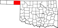
By statehood in 1907, when the old territorial Beaver County was divided into three new counties (Cimarron, Texas, and Beaver), the Oklahoma Panhandle held the highest population ever recorded in any census. Those old settlers who had squatted and stayed on uncertain land some twenty years before finally enjoyed vindication of their faith in themselves and the land.
Links
Free Records Search at Familysearch Org
Beaver County Cemetery Listings
Beaver County Cemetery Listings at Interment Net
Beaver County Cemetery Listings at Find A Grave
Oklahoma Birth Certificates
- Search for Oklahoma Birth Cetificates and how to order from the Vital Records Office.
State of Oklahoma Genealogy Records Guide
- Search for death certificates and how to order them from The Vital Records Office
Oklahoma State Archives
- Dept. of Libraries
Third Floor
200 NE 18th St.
Oklahoma City, Oklahoma 73105
Phone: (405) 522-3579 - The Oklahoma State Archives provides an excellent library of genealogy records including: Commissioner of Confederate Pensions Applications, 1915-33, Commissioner of Confederate Pensions Pension Files, 1915-49, U.S. District Land Office Homestead Registers, 1889-1908, Oklahoma Supreme Court Applications to the Bar, 1907-42, Oklahoma Board of Medical Examiners Deceased Files, 1907-86, Oklahoma Board of Pharmacy Deceased Pharmacist Files, 1907-75, and Oklahoma Board of Chiropractic Examiners Inactive License Files, 1921-84.
Oklahoma Genealogical Society Library and Archives
- 2100 N. Lincoln Blvd.
Oklahoma City, Oklahoma 73105-4997
Phone: (405) 522-5225 - The Oklahoma Genealogical Society maintains a library and archives that the public is allowed to visit. The Library and Archives contains over 62,000 volumes with emphasis on Oklahoma, Native American, and western history. In addition to these materials -- many of which are rare and out-of-print -- the library also houses a number of special collections.
111 West 2nd St.
Beaver, OK 73932
Phone (580)625-3141
111 West 2nd St.
Beaver, OK 73932
Phone (580)625-3191
Email Lists and Query Boards
Adjacent Counties
Meade County, Kansas | Clark County, Kansas | Seward County, Kansas
Lipscomb County, Texas | Ochiltree County, Texas